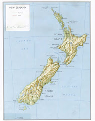
just thought i'd throw this map up for anyone who wants help visualizing our travels since september. start at picton (top right) and travel counter-clockwise around the outside until you get to christchurch, then head west and connect the dots clockwise until you get back down to christchurch. the thick black lines are the routes we've traveled by car, bus, or train, the orange bits are sections that we've completed on foot, and the circled city names are places that we've stayed at least overnight. as a reference, the length of the south island is roughly the distance from washington, dc to bangor, maine, or from san diego to redding, or from san antonio to albuquerque, or from minneapolis to indianapolis, or from orlando to nashville. these are my finger measurements, so i'm not claiming precision with these comparisons.
-rachel


No comments:
Post a Comment