hello again!
after flipping through guidebooks and speaking with a friendly woman at the DOC office, we've figured out where we're headed next. we'll be bypassing the rest of the north island for now, opting instead to hike the queen charlotte track and generally bum around the marlborough sounds for about a week. on thursday, we'll take the nakedbus (like the megabus - just $25/person!) down to wellington, where we'll spend the night before hopping on the cook strait ferry that will transport us to picton, at the top of the north island. in picton we'll arrange water transport to the start of the 4-day track and make any final arrangements that we need. today we bought a backcountry hut pass that will let us stay in most DOC huts for free, so the lodging costs once we get to the sounds will be minimal. this will certainly be a change from the last few weeks of hiking, as we'll now have plenty of huts and campsites to choose from and virtually no road walking. hooray!
after we've exhausted our interest in the sounds, the tentative plan is to head west to the town of nelson and maybe hit up the ever-popular abel tasman national park or the more quiet kahurangi national park. we have some options. don't be jealous!
-rachel and bryan
Tuesday, September 29, 2009
Monday, September 28, 2009
whangarei to auckland, part 2
thursday, september 24
dome valley to puhoi, 14.25 miles
last night's campground is a bit of an oddity. it's called sheepworld, as it is also a sort of farm where visitors can learn more about sheep and view sheep shows, and is known for its hot pink live sheep roaming around on the front lawn. i can't imagine that this would lure me in if i were driving by, as there doesn't seem to be any real attraction beyond "look - there's a pink sheep!", 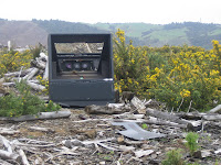 but maybe they're making bank on the gimmick. we didn't have time to explore anything beyond the little campground, which was a bit sketchy. i picked a dead mosquito and another unidentifiably small insect out of my alfredo before eating it last night.
 but maybe they're making bank on the gimmick. we didn't have time to explore anything beyond the little campground, which was a bit sketchy. i picked a dead mosquito and another unidentifiably small insect out of my alfredo before eating it last night.
this morning was the kind of morning that i'd be pleased to wake up to every day. after bill picked us up, he treated us to coffees at the cafe and we chatted about the morning's newspaper headlines. the new zealand herald ran a story about a woman living in a camper who woke up in the middle of the night to find that she'd been lovingly stroking a huge water rat instead of her pet cat, resulting in a nasty bite on the lip. remind me not to stay at spring creek holiday park.
our hiking today, only partially in the rain, took us up to moirs hill on gloriously flat logging roads before marching us along fencelines past cows and goats. the goats, unfortunately, tend to scurry away before we can get much of a chance to gawk at them. the walks through pastures, while interesting for the sake of animal-watching, are dreaded for their unavoidably pitted ground caused by heavy hooves plodding through thick mud. it's surprising that we've escaped ankle injury, as these fields can really be quite dangerous.
camped, for the first time in a while, freedom-style in the forest. today's well-balanced diet:
breakfast: chocolate-honey granola bar and a mocha
lunch/snack: peanut butter sandwich and another granola bar
dinner/snack: peanut butter sandwich, another granola bar, and trail mix
lunch/snack: peanut butter sandwich and another granola bar
dinner/snack: peanut butter sandwich, another granola bar, and trail mix
friday, september 25
puhoi to waiwera, 8 miles
a wonderful day on the trail (maybe a favorite?). near 10 am, we wandered into puhoi, a tiny village originally settled by 200 bohemians who came for the free land and found themselves dropped off in an isolated section of dense bush. again, it was tiny, but they played up the historic aspect pretty well and we lingered for a few hours. unfortunately, it was not 1-4 pm on a summer weekday (these are actually surprisingly broad hours for 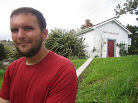 such a small town), so we couldn't visit the bohemian museum. thankfully, the "reservations essential" puhoi river canoes let us rent a couple of kayaks without a reservation, so we pushed out into the puhoi river to tackle an 8 km section where there is currently no foot trail. as we were paddling downstream on an outgoing tide with a strong tailwind, we found ourselves at wenderholm regional park disappointingly early and wandered around the park for nearly an hour before the van arrived to swap our packs for their boats. the kayaking was great fun, and got us planning our next vacations when we return to the midwest (boundary waters? apostle islands?). walked just a mile or two over the hill to waiwera, where we hit up the hot pools and took the opportunity to do laundry before the heavy rain set in again for the evening.
 such a small town), so we couldn't visit the bohemian museum. thankfully, the "reservations essential" puhoi river canoes let us rent a couple of kayaks without a reservation, so we pushed out into the puhoi river to tackle an 8 km section where there is currently no foot trail. as we were paddling downstream on an outgoing tide with a strong tailwind, we found ourselves at wenderholm regional park disappointingly early and wandered around the park for nearly an hour before the van arrived to swap our packs for their boats. the kayaking was great fun, and got us planning our next vacations when we return to the midwest (boundary waters? apostle islands?). walked just a mile or two over the hill to waiwera, where we hit up the hot pools and took the opportunity to do laundry before the heavy rain set in again for the evening.
 we've been meeting more people lately who are familiar with the te araroa. the owners of the canoe rental shop estimated that we were around the 15th hikers to stop in (apparently the trampers never book ahead) and a man that we met at wenderholm had hiked much of the trail in sections, but said that we were the first he'd met to be hiking it on a longer-term basis.
saturday, september 26
waiwera to stillwater, 12.5 miles
certainly this is the part of the trail that was designed to create awkward encounters for trampers. the day ends with a crossing of the weiti river, a river large enough to require a boat crossing but not large enough to operate a ferry service. unfortunately, by the time you get down to the jetty you're far away from any detour option, but the route takes you there anyway, with the optimistic but unrealistic suggestion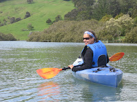 "you might be able to get a ride across with local boaties." said boaties were, we found, less than eager to transport us, and we would have been stuck had it not been for a german man who lives next to the boat club and had been suggested by the te araroa trust as a potential ride. he was just getting ready to go out when we came knocking on his door, but kindly ferried us across in his tiny dinghy anyway. thanks, gunter.
 "you might be able to get a ride across with local boaties." said boaties were, we found, less than eager to transport us, and we would have been stuck had it not been for a german man who lives next to the boat club and had been suggested by the te araroa trust as a potential ride. he was just getting ready to go out when we came knocking on his door, but kindly ferried us across in his tiny dinghy anyway. thanks, gunter.
the earlier part of the day had been anxiety-producing as well, when a long stretch of rock scrambling along the coast ended with us wading in to shore, having left just barely in time that morning (7:30, an hour after low tide). it's just difficult to pack up in the rain, you know? the rock scrambling routes are a ton of fun, though, as there's an element of danger and you have to be consstantly focused on your next step. i suppose it's a bit like the experience of rock climbing.
ran out of food today, having passed by the orewa supermarkets 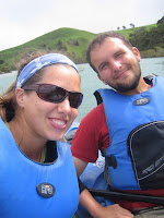 in our eagerness to get to an i-site (info center) and being under the impression that we'd be walking through the heart of whangaparaoa on our way down to the river. bryan sniffing hopefully into a nearly-empty peanut butter jar was a pitiful (but hilarious) sight. finished off our brothy soups and settled into a less-than-sparkling cabin (another upgrade) for the night.
 in our eagerness to get to an i-site (info center) and being under the impression that we'd be walking through the heart of whangaparaoa on our way down to the river. bryan sniffing hopefully into a nearly-empty peanut butter jar was a pitiful (but hilarious) sight. finished off our brothy soups and settled into a less-than-sparkling cabin (another upgrade) for the night.
sunday, september 27
stillwater to takapuna, 13.5 miles
discovered shortly after we set out proudly at 7 am (earliest start yet!) that we had forgotten about daylight savings time, making it 8 am instead. summer is certainly in the air, especially as today is the first mostly nice day in over a week and the 2-week school holidays began this weekend. our first hours were spent on the okura bush track along with 20 or so others who kept bounding by us in either direction, apparently involved in some sort of race.
due to the recent rain, our estuary crossing became surprisingly deep - hip level at the location that was supposed to be an "in case you don't want to get too wet" alternative from the intended crossing spot. my REI pants proved themselves by drying out quickly, and we soon found a four-square (grocery store) where we ate a lunch that involved sandwiches and three forms of chocolate: nutella on a roll, a cadbury caramello bar, and arnott's orange chocolate biscuits. can you tell what we crave on the trail? (though i guess you all know i don't need any excuse to crave chocolate...)
the 15-mile north shore city coastal walk is the last stretch of trail north of auckland, and bounces along from bay to bay past million-dollar homes that are at once all completely unique and all the same (lots of nautical themes, walls of windows, telescope in the  corner of the top level, high fences to deter peeping backpackers like us). i expected this portion to bore us with long stretches of suburban sidewalk, but it turned out to be surprisingly well done. everyone was out on the beach today - kayakers, jet skiiers, kite flyers, kids on playgrounds, readers, couples - and we stopped and talked to three separate older couples about our trip. the woman with the purple sunglasses was especially friendly, and she and her husband highly recommended both the routeburn and queen elizabeth trails on the south island.
 corner of the top level, high fences to deter peeping backpackers like us). i expected this portion to bore us with long stretches of suburban sidewalk, but it turned out to be surprisingly well done. everyone was out on the beach today - kayakers, jet skiiers, kite flyers, kids on playgrounds, readers, couples - and we stopped and talked to three separate older couples about our trip. the woman with the purple sunglasses was especially friendly, and she and her husband highly recommended both the routeburn and queen elizabeth trails on the south island.
instead of completing the last 6 miles down to the ferry terminal tonight, we opted to stay at a campground in takapuna, a posh suburb where you could easily blow a fortune on shopping and dining out. we made a reservation at a backpackers in auckland, so at least we know that we've got a bed when we arrive.
monday, september 28
takapuna to devonport, 6 miles
wrapped up the remaining miles (nice, but nothing noteworthy) by 9:45 this morning and hopped a fullers ferry over to the auckland side of the bay. on the to-do list while in town:
1) figure out the answer to "where next?"
2) send thank-you cards to some of the wonderful people that helped us out along the way
3) restock on pain reliever, athletic tape, and moleskine journals
4) pick up our bounce box
hopefully i'll get a chance to update again before we leave. if not, you'll hear from us next from _________
pictures:
1) an abandoned tv near moirs hill
2) waiting for the outgoing tide - taking a break near puhoi's little library
3 and 4) kayaking down the puhoi river
5) pools in the sand and rock along the okura bush track
-rachel
whangarei to auckland, part 1
i can't believe we haven't really updated since whangarei - it seems like such a long time ago now!

saturday, september 19
whangarei to brynderwyns, 15.25 miles (+.75)
hitched a ride out of town with a couple headed to the auckland airport to pick up their son. surprisingly, it was a nice car that stopped for us - usually it's people driving old beaters. on the way, we chatted about the weather, our travel plans, and the 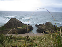 recent wildfires in australia (the husband works with/for the fire department) before they dropped us off in ruakaka. i should confess that ruakaka is 8 kms (5 miles) south of the official start of the part of the trail, but as the 5 miles entailed more beach walking, we allowed ourselves this little fudge.
 recent wildfires in australia (the husband works with/for the fire department) before they dropped us off in ruakaka. i should confess that ruakaka is 8 kms (5 miles) south of the official start of the part of the trail, but as the 5 miles entailed more beach walking, we allowed ourselves this little fudge.
 watched the water expectantly in the morning, as other walkers had mentioned that dolphins were patrolling the shoreline, but all we spotted were birds. headed inland on a high-tide bypass through waipu after a few miles. the going was quick (10 miles by lunchtime!) but the road walking was a bore. picked up a game that we invented in the kaiikanui forest (it needs a name - any suggestions?) - taking turns, we work through the alphabet in movies. for example, today we were on the letter F, so each movie had to start with the letter F and have the second letter somewhere in it; flashdance (fa), ferris bueller's day off (fb), the french connection (fc), freaky friday (fd), etc. we had been stuck on fj for hours until bryan remembered full metal jacket.
we camped pretty early (3:30) in the forest, passing up a few potential sites that were, in bryan's words, "fixer-uppers, not move-in ready".
sunday, september 20
brynderwyns to mangawhai heads, 3 miles (+2)
brynderwyns to mangawhai heads, 3 miles (+2)
as evidenced by today's pathetic mileage, this was no arduous day of walking. in fact, we cheated (these little fudges are adding up to one bigger fudge, huh?) and skipped an 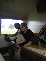 entire 4-mile section, opting instead for the much more direct road route into mangawhai heads. in our defense, this change was made at the encouragement of des and min, who invited us to pause for tea and anzac biscuits (cookies) on the site of their burned-down bach (holiday home) after watching us walk by a few times in search of a relocated section of the brynderwyn walkway. they had just returned from one of many trips to the u.s.; des had even worked in iowa for a while and visited the mall of america while he was there. they were just some of the many people who first guess that we're canadian, of which we're quite proud as it identifies us as the northerners that we are trying so hard to be and distances us from the classic american tourist. talked with them for a while about the state of the church in new zealand. from their perspective, the church is much less involved in the community here than in the states, leading to a declining portion of kiwis attending services in a country that was apparently once known for its multitude of churches.
 entire 4-mile section, opting instead for the much more direct road route into mangawhai heads. in our defense, this change was made at the encouragement of des and min, who invited us to pause for tea and anzac biscuits (cookies) on the site of their burned-down bach (holiday home) after watching us walk by a few times in search of a relocated section of the brynderwyn walkway. they had just returned from one of many trips to the u.s.; des had even worked in iowa for a while and visited the mall of america while he was there. they were just some of the many people who first guess that we're canadian, of which we're quite proud as it identifies us as the northerners that we are trying so hard to be and distances us from the classic american tourist. talked with them for a while about the state of the church in new zealand. from their perspective, the church is much less involved in the community here than in the states, leading to a declining portion of kiwis attending services in a country that was apparently once known for its multitude of churches.
received more hospitality once in mangawhai heads, where the campground owner let us stay in a small camper, milo #7, for no extra charge. this is especially appreciated tonight, as it looks like it might rain again. our usual 6:30 alarm woke us up to rain pounding on the fly this morning, so, knowing that we had a very light day of trekking ahead of us, we slept and read until finally rousing for good around 10 am, almost 3 hours behind schedule. it's on these rainy weekend mornings that our homesickness most presents itself, manifesting in long conversations about what we'd be doing if we were at home. this morning, we decided that we'd attend the 9 am church service, stopping first for six cheese bagels from einstein's, then return home for a sandwich lunch before turning on a football game (bryan) and heading to the caribou on 77 & 66th st for some reading time. in the evening, we'd invite some of our lovely friends over for pizza and games. a perfect rainy sunday.
monday, september 21
mangawhai heads to pakiri beach, 17 miles

the plan was to camp at te arai point, a free campsite on the beach, but when we arrived here at lunchtime we figured that we really couldn't stop quite yet and pressed on for another 8 miles to the end of pakiri beach. the weather was maddening - constant strong winds blowing in from the east with on-again, off-again showers. arrived at the campsite wet and tired, but glad for a dry room with a tv and less miles tomorrow. my knee started acting up after lunch today, so i've been rocking a knee brace that i plan to keep on for style long after the knee returns to normal. it makes me look athletic.
tuesday, september 22
pakiri beach to matakana, 10 miles
started the day with a steep climb (380 m) across pastures, buffeted ceaselessly by a powerful wind that seemed to be targeting us at our exposed location. we started later than we should have (after 10 - oops!) and had to work hard to make up for this, 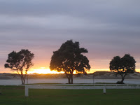 not stopping for lunch until after 2. the tamahunga track through the omaha state forest, though muddy, was well worth the time invested.
 not stopping for lunch until after 2. the tamahunga track through the omaha state forest, though muddy, was well worth the time invested.
 we were planning to hitchhike off the trail to warkworth where budget accomodation was available, but as we're facing a long day tomorrow and it's bryan's bday, we splurged on a motel room instead. (side note: i believe i told someone shortly before i left that i would never stay in a motel, only a hotel - this was foolish of me. motels can be lovely things, and i'm sorry to have degraded them with my thoughtless comment.) we spent the evening watching the apparently popular primetime soaps "neighbours" and "home and away" in addition to our regular favorites, "how i met your mother" and "family guy". beautiful. took advantage of the electric teapot and complimentary milk cartons and made plenty of tea and hot chocolate for ourselves.
wednesday, september 23
matakana to dome valley, 13 miles
after an exhausting 9-hour day, we emerged from the forest at a 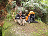 cute cafe on highway 1, along which we needed to walk for another few miles to end up at a campground. our decision to stop for a hot chocolate was good one, as it landed us a ride to the campground and a ride back to the start of the trail tomorrow, thanks to bill and jocelyn (the cafe owners). got upgraded to a camper again, a great blessing as it's been pouring for the better portion of the day. today's route gets a thumbs up - as we get closer to to auckland, the trails are becoming better marked and better developed. found the perfect lunch spot on a big rock jutting out over the waiwhiu stream.
 cute cafe on highway 1, along which we needed to walk for another few miles to end up at a campground. our decision to stop for a hot chocolate was good one, as it landed us a ride to the campground and a ride back to the start of the trail tomorrow, thanks to bill and jocelyn (the cafe owners). got upgraded to a camper again, a great blessing as it's been pouring for the better portion of the day. today's route gets a thumbs up - as we get closer to to auckland, the trails are becoming better marked and better developed. found the perfect lunch spot on a big rock jutting out over the waiwhiu stream.
to be continued...
pictures:
1) some pretty stretch of beach somewhere. before pakiri beach, maybe?
2) taking off the wet boots in the 70s camper that we affectionately called "milo"
3) another cute picture of bryan. how adorable is he?
4) the sunrise over mangawhai heads
5) checking the gps at our lunch spot over the stream.
auckland: the second time around
hi friends! bryan and i are pleased to announce that we have made it back down to auckland, having walked 358 miles along the te araroa trail from cape reinga in 31 hiking days, an average of about 11.5 miles a day (that doesn't sound very impressive, does it?). i haven't felt quite as much elation as i expected to, but that's probably the way it should be, leaving the celebrations for those who finish more than 20% of the trail. having arrived in yet another downpour may have affected my mental state as well.
we have zero idea where we're going next. zero. we'll spend tonight and tomorrow night in the latana lodge in parnell (just east of downtown auckland), perusing the internet and lonely planet guidebooks for suggestions. we'd like to continue hiking, preferably in the south island, if we can work out a good long-term route, but it's still a bit chilly there and the money isn't as endless as it once seemed. two days ago we were sure that we'd stop for a few months and get a job in some small town, but now we're not so sure...check back soon for an update!
rachel
Saturday, September 26, 2009
from waiwera
hey all! i've only got a minute or two, but just wanted to let you know that we're getting close to auckland and should arrive either tomorrow night or the night after. it's rained all but one day (bryan's bday, on which the weather hurled itself at us in the form of strong wind) since we left whangarei, so we're hoping for the weather to clear up again and let us dry off.
spent last night at a campground in waiwera, which is famous for its hot pools resort. our campground gave us a great discount, so we spent yesterday evening soaking in the movie pool, which was 100 degrees and showed music videos. hope to update by monday or tuesday!
rachel
spent last night at a campground in waiwera, which is famous for its hot pools resort. our campground gave us a great discount, so we spent yesterday evening soaking in the movie pool, which was 100 degrees and showed music videos. hope to update by monday or tuesday!
rachel
Friday, September 18, 2009
kerikeri to whangarei, part 2
sunday, september 13
kaiikanui forest to whananaki north, 5.5 miles (+9)
this day realy should have been an awful one, but somehow it turned out positively after all. after a surprisingly restful night of sleep, we headed out on a beautiful but misty sunday morning into the kaiikanui forest. our directions advised us to take the unmarked but well-formed track that led into the forest for 6 kms, and then follow a very rough track for 1 km to meet up with the other 6 kms across private land. we hiked most, if not all, of the initial 6 kms but couldn't find any sign of a track from there, and after an hour and a half of exploring potential trail leads around the last trail marking we could spot, bryan made the difficult but correct call to turn around and head back out. i could never have made that decision - i'm much too stubborn. so, 5 hours after entering the forest, just when we expected to be exiting it on the other end, we found ourselves back where we'd started. we had, appropriately, just read and reflected on the portion of james 4 that reminds us not to boast about the plans that we've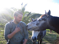 made, as we don't know what the day will hold. nice.
we started down the road, looking for another way to get to whananaki north by sunset, and were able to get a ride in the back of a pickup truck amongst the fishing gear thanks to two guys from auckland, saving us about 7 miles. once on whananaki north road, we walked the next 5 miles, but were then picked up by a family that was actually heading the other way but turned around to help us out. they dropped us near the entrance to the whananaki estuary track, the last mile and a half of the day, and the spot where we both received particularly painful bites by an electric fence. we really should be warned about these electric fences in the te araroa route details - this is not the first that we've been "shocked" :) to find a current running through a fence that crossed our path.
we stopped by a dairy just before closing time for some snacks, and received a very welcome surprise at being upgraded to a cabin at the holiday park, where the owner called our hiking "inspirational". wished we could have stayed here longer, but the trail was beckoning, as always.
monday, september 14
whananaki north to tutukaka, 14.5 miles (+2)
today is our second anniversary! thankfully, it was one that we'll be able to look back on with happy memories, as the hikes today were especially good and we had a tasty meal to finish off the day. perhaps due to the strange but filling meal of instant potatoes and spicy noodle soup the night before, we cranked out the miles with energy to spare. the whananaki coastal track woudn along coastal farmland with plenty of dramatic views of the surf (plus a nic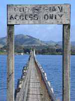 e but accidental detour to a memorial for a french ship that sank in 1975), the matapouri connection brought us alongside the surfing hotspots of sandy bay and wooley's bay, and the matapouri bush track took us away from the coast for the afternoon and through some recently logged areas. we even finished the last section in half an hour less than the directions estimated - a very rare feat! walked the last 3 km into ngunguru (nung-a-roo, apparently), only to find that they didn't have any budget accommodations (hostel/campground), so we trotted back north (the direction from which we'd come) to tutukaka and found a spot at a holiday park. went out to dinner, our first real date in months, at a restaurant that was a bit too nice for our grungy selves, but it was the only one open on mondays and we enjoyed a very tasty seafood chowder as the stars came out over the marina. it's strange for us to be out at night - it feels like we're playing grown-up. our feet were killing us by the end of the day, especially mine, which refuse to grow calluses and keep blistering in the same spots. ouch!
tuesday, september 15
tutukaka to pataua south, 19.25 miles (+1)
new distance record - 20 miles in 10 hours on the road. though exhausted, we're quite proud of the day's total. only 2.5 of these miles were on a real track, the mackerel forest track; the rest were on busy roads where we were offered plenty of rides that we begrudgingly turned down. a bland day overall, though the lateness of our arrival (6:45 pm - the sun sets around 6:30) meant that we were privy to some beautiful sunsets that we generally miss. restocked in tutukaka this morning at an expensive general store, so the packs felt especially heavy. the nutella is worth its weight, though, and will be nothing more than an empty jar in a day or two. stayed, again, at a campground - we'd much prefer a spot in the woods, but the east coast is just too developed and we don't have a choice.
wednesday, september 16
pataua south to ocean beach, 11.75 miles (+1)
the morning got off to a promising start, the morning sun having dried out our rainfly for the first time in weeks and the campground owner charging us less than half of the usual rate. we had been concerned about our first tramp of the day, a low-tide only route along and then across an estuary, but fortunately we happened to be setting out near low tide and didn't have to scramble to find an alternate route. the soft sand was pocked with small pools of water that hid little still-life scenes of red, green and purple shells and sea life - colors that i wouldn't normally put together but that are stunning when they occur naturally. we waded through the river at its shallowest point, tiny crabs skittering underfoot, and reluctantly climbed over farm gates back to the road to tackle the relatively short kauri mountain. had the track's orange arrow been pointing in the logical direction at a critical turn, this would have been a quick route; instead, we huffed up a substantial hill only to find ourselves a half mile off the trail.
the day finished off with 4 miles of beach walking that reminded us of why we hate beach walking, passing small bay with nearly a dozen surfers in the water before climbing steeply up a cliff to hit the ridgeline of the bream head track. this early part of the track was through grass, allowing us constant views over the ocean to make up for the burning in our calves. during this hour of constant steep ascent, we were pleased to make it 20 steps before rewarding ourselves with a long breather. despite the lack of a flat surface (which we would notice acutely as we slid towards the foot of the tent all night long, coming to call this camp "slanty camp"), we set up camp at the first sight of the start of the forest. we're hoping that having tackled this climb today means arriving in whangarei tomorrow.
thursday, september 17
ocean beach to whangarei, 7.25 miles
we're constantly impressed by the kindness and generosity of the people that we run into. after completing the remainder of the challenging but, thankfully, well-marked and formed bream head track in 4 hours, we walked 4 miles on the road along a series of bays, deciding to skip a 2-mile track that would have detoured us from the main road. our plans to spend a few days in northland's largest city, whangarei, took us off the main trail route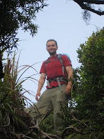 and meant that we'd need to hitchhike the 15 or so miles into town. before we could even put out the thumb, an older couple heading into whangarei for a load of fertilizer offered us a ride, which we gratefully accepted. apparently they'd seen us walk by from their home and had almost invited us in for a cup of tea. besides dropping us off at the door of the hostel, they highlighted sights along the way, took us for a brief detour to a good lookout point, and even invited us to spend a few nights with them at their home. regretfully, we decided to decline their offer, as we were anxious to get into town after having been on the trail for 10 days straight and are running far behind our original schedule. the end of a hitchhiking ride can be so rushed, scrambling to get our belongings and stay out of traffic's way, that i fear we don't always fully express our appreciation. anyway, we're now staying at the fairly centrally-located bunkdown lodge, which protests its mediocre 73% user rating with the note "unjustified rating-check us out!" in the hostel guide. it's not a bad spot, though cleanliness doesn't seem to be its forte. found a pizza hut for dinner (in all fairness, the cute local spots were either closed or too expensive) and settled in for the evening with a viewing of swiss family robinson. met a german woman who's been travelling solo through asia and australia, as well as two brits who took sabbaticals to explore nz for a few months. planning to hitchhike out of town and back to the eastern beaches on saturday. not long enough.
pictures:
1-bryan saying hello to some horses while crossing a pasture
2-a pedestrian bridge connecting whananaki north with whananaki south
3-along the coast - by ocean beach, maybe?
4-finishing the day with a steep hike up towards bream head
5-bryan climbing up to the highest point along the bream head track
time's up - we'll update again in a week or so. not sure yet where we'll stop between here and auckland - hoping to make it in 10 hiking days.
rachel
kaiikanui forest to whananaki north, 5.5 miles (+9)
this day realy should have been an awful one, but somehow it turned out positively after all. after a surprisingly restful night of sleep, we headed out on a beautiful but misty sunday morning into the kaiikanui forest. our directions advised us to take the unmarked but well-formed track that led into the forest for 6 kms, and then follow a very rough track for 1 km to meet up with the other 6 kms across private land. we hiked most, if not all, of the initial 6 kms but couldn't find any sign of a track from there, and after an hour and a half of exploring potential trail leads around the last trail marking we could spot, bryan made the difficult but correct call to turn around and head back out. i could never have made that decision - i'm much too stubborn. so, 5 hours after entering the forest, just when we expected to be exiting it on the other end, we found ourselves back where we'd started. we had, appropriately, just read and reflected on the portion of james 4 that reminds us not to boast about the plans that we've
 made, as we don't know what the day will hold. nice.
we started down the road, looking for another way to get to whananaki north by sunset, and were able to get a ride in the back of a pickup truck amongst the fishing gear thanks to two guys from auckland, saving us about 7 miles. once on whananaki north road, we walked the next 5 miles, but were then picked up by a family that was actually heading the other way but turned around to help us out. they dropped us near the entrance to the whananaki estuary track, the last mile and a half of the day, and the spot where we both received particularly painful bites by an electric fence. we really should be warned about these electric fences in the te araroa route details - this is not the first that we've been "shocked" :) to find a current running through a fence that crossed our path.
we stopped by a dairy just before closing time for some snacks, and received a very welcome surprise at being upgraded to a cabin at the holiday park, where the owner called our hiking "inspirational". wished we could have stayed here longer, but the trail was beckoning, as always.
monday, september 14
whananaki north to tutukaka, 14.5 miles (+2)
today is our second anniversary! thankfully, it was one that we'll be able to look back on with happy memories, as the hikes today were especially good and we had a tasty meal to finish off the day. perhaps due to the strange but filling meal of instant potatoes and spicy noodle soup the night before, we cranked out the miles with energy to spare. the whananaki coastal track woudn along coastal farmland with plenty of dramatic views of the surf (plus a nic
 e but accidental detour to a memorial for a french ship that sank in 1975), the matapouri connection brought us alongside the surfing hotspots of sandy bay and wooley's bay, and the matapouri bush track took us away from the coast for the afternoon and through some recently logged areas. we even finished the last section in half an hour less than the directions estimated - a very rare feat! walked the last 3 km into ngunguru (nung-a-roo, apparently), only to find that they didn't have any budget accommodations (hostel/campground), so we trotted back north (the direction from which we'd come) to tutukaka and found a spot at a holiday park. went out to dinner, our first real date in months, at a restaurant that was a bit too nice for our grungy selves, but it was the only one open on mondays and we enjoyed a very tasty seafood chowder as the stars came out over the marina. it's strange for us to be out at night - it feels like we're playing grown-up. our feet were killing us by the end of the day, especially mine, which refuse to grow calluses and keep blistering in the same spots. ouch!
tuesday, september 15
tutukaka to pataua south, 19.25 miles (+1)
new distance record - 20 miles in 10 hours on the road. though exhausted, we're quite proud of the day's total. only 2.5 of these miles were on a real track, the mackerel forest track; the rest were on busy roads where we were offered plenty of rides that we begrudgingly turned down. a bland day overall, though the lateness of our arrival (6:45 pm - the sun sets around 6:30) meant that we were privy to some beautiful sunsets that we generally miss. restocked in tutukaka this morning at an expensive general store, so the packs felt especially heavy. the nutella is worth its weight, though, and will be nothing more than an empty jar in a day or two. stayed, again, at a campground - we'd much prefer a spot in the woods, but the east coast is just too developed and we don't have a choice.
wednesday, september 16
pataua south to ocean beach, 11.75 miles (+1)
the morning got off to a promising start, the morning sun having dried out our rainfly for the first time in weeks and the campground owner charging us less than half of the usual rate.
 we had been concerned about our first tramp of the day, a low-tide only route along and then across an estuary, but fortunately we happened to be setting out near low tide and didn't have to scramble to find an alternate route. the soft sand was pocked with small pools of water that hid little still-life scenes of red, green and purple shells and sea life - colors that i wouldn't normally put together but that are stunning when they occur naturally. we waded through the river at its shallowest point, tiny crabs skittering underfoot, and reluctantly climbed over farm gates back to the road to tackle the relatively short kauri mountain. had the track's orange arrow been pointing in the logical direction at a critical turn, this would have been a quick route; instead, we huffed up a substantial hill only to find ourselves a half mile off the trail.
the day finished off with 4 miles of beach walking that reminded us of why we hate beach walking, passing small bay with nearly a dozen surfers in the water before climbing steeply up a cliff to hit the ridgeline of the bream head track. this early part of the track was through grass, allowing us constant views over the ocean to make up for the
 burning in our calves. during this hour of constant steep ascent, we were pleased to make it 20 steps before rewarding ourselves with a long breather. despite the lack of a flat surface (which we would notice acutely as we slid towards the foot of the tent all night long, coming to call this camp "slanty camp"), we set up camp at the first sight of the start of the forest. we're hoping that having tackled this climb today means arriving in whangarei tomorrow.
thursday, september 17
ocean beach to whangarei, 7.25 miles
we're constantly impressed by the kindness and generosity of the people that we run into. after completing the remainder of the challenging but, thankfully, well-marked and formed bream head track in 4 hours, we walked 4 miles on the road along a series of bays, deciding to skip a 2-mile track that would have detoured us from the main road. our plans to spend a few days in northland's largest city, whangarei, took us off the main trail route
 and meant that we'd need to hitchhike the 15 or so miles into town. before we could even put out the thumb, an older couple heading into whangarei for a load of fertilizer offered us a ride, which we gratefully accepted. apparently they'd seen us walk by from their home and had almost invited us in for a cup of tea. besides dropping us off at the door of the hostel, they highlighted sights along the way, took us for a brief detour to a good lookout point, and even invited us to spend a few nights with them at their home. regretfully, we decided to decline their offer, as we were anxious to get into town after having been on the trail for 10 days straight and are running far behind our original schedule. the end of a hitchhiking ride can be so rushed, scrambling to get our belongings and stay out of traffic's way, that i fear we don't always fully express our appreciation. anyway, we're now staying at the fairly centrally-located bunkdown lodge, which protests its mediocre 73% user rating with the note "unjustified rating-check us out!" in the hostel guide. it's not a bad spot, though cleanliness doesn't seem to be its forte. found a pizza hut for dinner (in all fairness, the cute local spots were either closed or too expensive) and settled in for the evening with a viewing of swiss family robinson. met a german woman who's been travelling solo through asia and australia, as well as two brits who took sabbaticals to explore nz for a few months. planning to hitchhike out of town and back to the eastern beaches on saturday. not long enough.
pictures:
1-bryan saying hello to some horses while crossing a pasture
2-a pedestrian bridge connecting whananaki north with whananaki south
3-along the coast - by ocean beach, maybe?
4-finishing the day with a steep hike up towards bream head
5-bryan climbing up to the highest point along the bream head track
time's up - we'll update again in a week or so. not sure yet where we'll stop between here and auckland - hoping to make it in 10 hiking days.
rachel
kerikeri to whangarei, part 1
hi friends and family! it's been a while, huh? we've just completed a 10-day 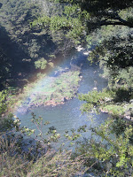 hiking stretch that, though interspersed with stays at campgrounds and holiday parks, hasn't given us access to the internet. since i'm running out of time on my current internet session, i'll post this in two parts.
tuesday, september 8
kerikeri to waitangi forest, 10.5 (+2) miles (the + numbers are miles that we walked that aren't on the trail - so extra miles to a campsite, places where we got lost, etc)
our packs felt especially heavy as we headed back on the trail, being recently loaded with a 6-day supply of food, but we pulled ourselves away from our cozy hostel with excitement about the miles ahead. the trail experience today was redeeming - the first 4 miles followed the kerikeri river down to rainbow falls and the stone store (historic missionary building), a track that reminded us of many of our recent experiences in our beloved minnesota state parks. it was almost exactly a year ago that we spent our first anniversary at wild river state park and walked a then-impressive 7 miles along the sunshine trail, one of a few trips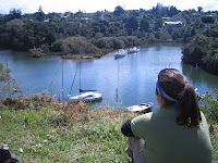 (the white oak trail with chris and daniela was another) that contributed towards our decision to try the te araroa.
after a road-margin interruption through an affluent neighborhood, we delved into the waitangi forest and found our most satisfying campsite to date on a flat patch among the pine needles. also spotted our first wild pigs, little black things that we initially mistook for bear cubs, despite knowing that new zealand is completely bear-free.
wednesday, september 9
waitangi forest to paihia, 7.5 miles
we allowed ourselves a tourist day today, scheduling a stop at the waitangi treaty grounds, where the maori and british government signed an agreement in 1840 essentially making nz a british colony. the $20 entry fee was surprisingly steep, as it's been raised significantly in the last year since the grounds became free for nz citizens, but in the end we were glad that we lightened our wallets. this area was a site of heavy missionary activity during the early colonization period, and one of the things that struck us was that they are always spoken of as having a positive contribution, serving as mediators during an especially intense season of tribal warfare. good for them. :)
spent the night at a holiday camp (a campground that typically includes a variety of lodging options - tent sites, campervan sites, small cabin/motel-style rooms, campervans for rent) between paihia and opua on the beautiful bay of islands (a top destination for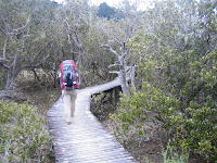 both tourists and vacationing kiwis), along a lovely stretch of the trail (the paihia-opua coastal walkway) that winds along the hills over the beach so as to be accessible even during high tide.
oh, i forgot to mention earlier - this morning on our way out of the forest we spoke with a forest management employee on a 4x4 who was loading dead possums into baskets on the front and back of his vehicle. there's such a possum problem throughout all of nz that they have poison traps all over to kill them off, and the guy we spoke to this morning said that he picked up 300 dead ones the day before. yet another example of non-native species wreaking havoc on the native environment.
jeremy, in response to your question - the only weta we've seen so far was in the auckland museum - blessed be the name of the Lord!
thursday, september 10
paihia to russell forest, 15 miles
while the day's walking ended with an hour-long uphill stretch that turned me into an ugly, tantrum-throwing child, it really did have some enjoyable sections. the rest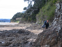 of the paihia-opua walkway was as dramatic and beautiful as the first half, the $1 ferry across the veronica channel, though very brief, was plenty exciting for us footsore travelers, and the okiato-russell walkway culminated in a long stretch of quiet boardwalk among the mangroves. this is what we came to nz for. the post-lunch miles, however, had little to recommend them - just 10 miles along the side of the road to the start of the russell forest. the things you can see on the side of the road - today's trends included cassette tapes and cheesecloth (miles apart from each other), as if someone had a basket full of these items and flung them out of the windows of a passing car at regular intervals. there's also what appears to be an illegal dumping ground off of a steep cliff on a remote section of the road - if you look down, you'll see old cars, trunk freezers, strollers, and plenty more, nestled in-between the trees. we camped on a nice flat spot just barely inside the forest.
friday, september 11
russell forest to russell forest, 9 miles
in the optimism of early morning we'd hoped to tackle all 13 miles of the forest today, but as the afternoon wore on, it became apparent that this plan would not be possible. overall, the russell forest experience was positive. despite it having rained last night, there were few muddy patches, and the trail was mostly wide and well-marked. we began running into trouble at around 3 pm, when the track grew increasingly narrow, squeezing us tightly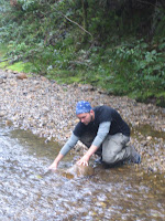 between green spiky bushes with yellow flowers (i have yet to find out what they're called) in a way that reminded me of sleeping beauty's prince hacking his way through the forest of thorns, though we had nowhere near as effective a weapon. around 4 pm, moments after we checked our position on the GPS and celebrated being within a half mile of the next junction, we encountered the result of a landslide that had obliterated the trail and made for some precarious traversing of obviously unstable territory. finally emerging on the other side, we discovered by the density of the bush that we hadn't actually made it back onto the path, and eventually gave up on an attempt to climb up to where we expected it to be. we soon came across a second landslide area, crossing this one without much difficulty but also without managing to position ourselves on the path again.
growing concerned about the amount of daylight remaining, when we came across the third landslide area we tried to scale the steep, raw hillside with the intent of bushwhacking across the summit to the other side of the hill, where we knew we could pick up the track again. this only succeeded in scaring us, as we couldn't get many solid hand- and footholds and the packs threw off our balance significantly, so we gave up and headed back to the lower levels of the slide area, right above the drop-off below. somehow, just when we were considering spending the night right there in the while bush, off the track, we stumbled across the trail and followed it to the next junction, where we set up shop under the protection of a cluster of trees. would rather not repeat this day again!
saturday, september 12
russell forest to kaiikanui forest, 14 miles (+1)
rained all through the night. rained all through the day. looks like it plans to rain all throughtonight as well. this is the kind of day that makes us long for the hot soup mixes in our packs (we usually gravitate away from cooking at night, since we just don't have the energy for it), but having to prepare it in such wet conditions is quite a deterrent. we stopped at a small dairy (shop w/ some groceries) at lunchtime and ate our meat pies & chips in the shelter of the adjacent burger shop's patio as the rain poured down especially violently. the burger place was, unfortunately, closed. thought seriously about getting off the trail and staying at a nearby motel, but the rain let up and we continued on. did 10 miles of road walking today, but the scenery (helena bay, teal bay, and plenty of farmland) was pretty and we didn't mind the walk.
upon arriving at the junction that marked 1.5 miles left to go, a DOC (department of conservation) sign advertised a campground with an arrow pointing down the road that we weren't planning to take, tempting us with the idea of toilets and flat campsites. it didn't, however, mention how far down the road it was, and we gave up after 3/4 of a mile without any sign of it (the GPS, though not always trustworthy, showed it to be a few miles in quite another direction). camped (illegally) in the forest instead. sometimes there just doesn't seem to be another option, given the surrounding areas. hopefully the te araroa trust will be able to address these problem spots, given some time.
pictures:
1-the rainbow of rainbow falls, on our way out of kerikeri
2-the perfect lunch spot, a high hill overlooking the old harbour in kerikeri
3-a boardwalk section on the paihia-opua coastal walkway
4-navigating a rocky spit on our way out of paihia
5-bryan refilling the water bottles at a stream in the russell forest. being particularly paranoid about the amount of water that we have, this has become his job. in the mornings, he even takes my camelbak out of my pack and fills it up with water from the extra bottles for convenience. what a nice guy!
part 2 to follow...
rachel
 hiking stretch that, though interspersed with stays at campgrounds and holiday parks, hasn't given us access to the internet. since i'm running out of time on my current internet session, i'll post this in two parts.
tuesday, september 8
kerikeri to waitangi forest, 10.5 (+2) miles (the + numbers are miles that we walked that aren't on the trail - so extra miles to a campsite, places where we got lost, etc)
our packs felt especially heavy as we headed back on the trail, being recently loaded with a 6-day supply of food, but we pulled ourselves away from our cozy hostel with excitement about the miles ahead. the trail experience today was redeeming - the first 4 miles followed the kerikeri river down to rainbow falls and the stone store (historic missionary building), a track that reminded us of many of our recent experiences in our beloved minnesota state parks. it was almost exactly a year ago that we spent our first anniversary at wild river state park and walked a then-impressive 7 miles along the sunshine trail, one of a few trips
 (the white oak trail with chris and daniela was another) that contributed towards our decision to try the te araroa.
after a road-margin interruption through an affluent neighborhood, we delved into the waitangi forest and found our most satisfying campsite to date on a flat patch among the pine needles. also spotted our first wild pigs, little black things that we initially mistook for bear cubs, despite knowing that new zealand is completely bear-free.
wednesday, september 9
waitangi forest to paihia, 7.5 miles
we allowed ourselves a tourist day today, scheduling a stop at the waitangi treaty grounds, where the maori and british government signed an agreement in 1840 essentially making nz a british colony. the $20 entry fee was surprisingly steep, as it's been raised significantly in the last year since the grounds became free for nz citizens, but in the end we were glad that we lightened our wallets. this area was a site of heavy missionary activity during the early colonization period, and one of the things that struck us was that they are always spoken of as having a positive contribution, serving as mediators during an especially intense season of tribal warfare. good for them. :)
spent the night at a holiday camp (a campground that typically includes a variety of lodging options - tent sites, campervan sites, small cabin/motel-style rooms, campervans for rent) between paihia and opua on the beautiful bay of islands (a top destination for
 both tourists and vacationing kiwis), along a lovely stretch of the trail (the paihia-opua coastal walkway) that winds along the hills over the beach so as to be accessible even during high tide.
oh, i forgot to mention earlier - this morning on our way out of the forest we spoke with a forest management employee on a 4x4 who was loading dead possums into baskets on the front and back of his vehicle. there's such a possum problem throughout all of nz that they have poison traps all over to kill them off, and the guy we spoke to this morning said that he picked up 300 dead ones the day before. yet another example of non-native species wreaking havoc on the native environment.
jeremy, in response to your question - the only weta we've seen so far was in the auckland museum - blessed be the name of the Lord!
thursday, september 10
paihia to russell forest, 15 miles
while the day's walking ended with an hour-long uphill stretch that turned me into an ugly, tantrum-throwing child, it really did have some enjoyable sections. the rest
 of the paihia-opua walkway was as dramatic and beautiful as the first half, the $1 ferry across the veronica channel, though very brief, was plenty exciting for us footsore travelers, and the okiato-russell walkway culminated in a long stretch of quiet boardwalk among the mangroves. this is what we came to nz for. the post-lunch miles, however, had little to recommend them - just 10 miles along the side of the road to the start of the russell forest. the things you can see on the side of the road - today's trends included cassette tapes and cheesecloth (miles apart from each other), as if someone had a basket full of these items and flung them out of the windows of a passing car at regular intervals. there's also what appears to be an illegal dumping ground off of a steep cliff on a remote section of the road - if you look down, you'll see old cars, trunk freezers, strollers, and plenty more, nestled in-between the trees. we camped on a nice flat spot just barely inside the forest.
friday, september 11
russell forest to russell forest, 9 miles
in the optimism of early morning we'd hoped to tackle all 13 miles of the forest today, but as the afternoon wore on, it became apparent that this plan would not be possible. overall, the russell forest experience was positive. despite it having rained last night, there were few muddy patches, and the trail was mostly wide and well-marked. we began running into trouble at around 3 pm, when the track grew increasingly narrow, squeezing us tightly
 between green spiky bushes with yellow flowers (i have yet to find out what they're called) in a way that reminded me of sleeping beauty's prince hacking his way through the forest of thorns, though we had nowhere near as effective a weapon. around 4 pm, moments after we checked our position on the GPS and celebrated being within a half mile of the next junction, we encountered the result of a landslide that had obliterated the trail and made for some precarious traversing of obviously unstable territory. finally emerging on the other side, we discovered by the density of the bush that we hadn't actually made it back onto the path, and eventually gave up on an attempt to climb up to where we expected it to be. we soon came across a second landslide area, crossing this one without much difficulty but also without managing to position ourselves on the path again.
growing concerned about the amount of daylight remaining, when we came across the third landslide area we tried to scale the steep, raw hillside with the intent of bushwhacking across the summit to the other side of the hill, where we knew we could pick up the track again. this only succeeded in scaring us, as we couldn't get many solid hand- and footholds and the packs threw off our balance significantly, so we gave up and headed back to the lower levels of the slide area, right above the drop-off below. somehow, just when we were considering spending the night right there in the while bush, off the track, we stumbled across the trail and followed it to the next junction, where we set up shop under the protection of a cluster of trees. would rather not repeat this day again!
saturday, september 12
russell forest to kaiikanui forest, 14 miles (+1)
rained all through the night. rained all through the day. looks like it plans to rain all throughtonight as well. this is the kind of day that makes us long for the hot soup mixes in our packs (we usually gravitate away from cooking at night, since we just don't have the energy for it), but having to prepare it in such wet conditions is quite a deterrent. we stopped at a small dairy (shop w/ some groceries) at lunchtime and ate our meat pies & chips in the shelter of the adjacent burger shop's patio as the rain poured down especially violently. the burger place was, unfortunately, closed. thought seriously about getting off the trail and staying at a nearby motel, but the rain let up and we continued on. did 10 miles of road walking today, but the scenery (helena bay, teal bay, and plenty of farmland) was pretty and we didn't mind the walk.
upon arriving at the junction that marked 1.5 miles left to go, a DOC (department of conservation) sign advertised a campground with an arrow pointing down the road that we weren't planning to take, tempting us with the idea of toilets and flat campsites. it didn't, however, mention how far down the road it was, and we gave up after 3/4 of a mile without any sign of it (the GPS, though not always trustworthy, showed it to be a few miles in quite another direction). camped (illegally) in the forest instead. sometimes there just doesn't seem to be another option, given the surrounding areas. hopefully the te araroa trust will be able to address these problem spots, given some time.
pictures:
1-the rainbow of rainbow falls, on our way out of kerikeri
2-the perfect lunch spot, a high hill overlooking the old harbour in kerikeri
3-a boardwalk section on the paihia-opua coastal walkway
4-navigating a rocky spit on our way out of paihia
5-bryan refilling the water bottles at a stream in the russell forest. being particularly paranoid about the amount of water that we have, this has become his job. in the mornings, he even takes my camelbak out of my pack and fills it up with water from the extra bottles for convenience. what a nice guy!
part 2 to follow...
rachel
Tuesday, September 8, 2009
ahipara to kerikeri
hello again! with our third post in two days, i'm afraid we're in danger 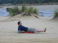 of overblogging and losing your interest. thought some of you might want a day-by-day account, though, so here it is.
tuesday, september 1 ahipara to herekino forest, 9.5 miles
a treacherous day after such a nice long rest! the first 5-mile section was road walking, the first of many, but fortunately we were able to take a break for a "cuppa" (cup of tea/coffee/etc) and some cookies at the home of karen, a friendly mother of two young kids that we first met two days ago when arriving in ahipara. she'd spent a year in casper, wyoming on a basketball scholarship in college and had also lived in the south island's university town of dunedin, so we were able to talk a bit about both where we'd come from (u.s.) and where we would be heading (south island) in a few months.
no hospitable people for a while after that, though - the forest seems to make no friends, only enemies. the track was mostly mud and climbed steeply immediately after entering. bryan remarked accurately that it felt more like a jungle than a forest. the only relief was a brief walk along the only well-formed part of the trail, an old logging road. my feet are constantly wet. camped for the night on the trail, on the flattest and driest section that we could find, which really isn't saying much. we're already behind schedule,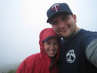 having made it only halfway through the forest, and will likely have to extend this section by as many as two days. :(
wednesday, september 2 herekino forest to raetea forest - 13.5 miles
nothing to write home about here. finally struggled out of the dang herekino forest around noon, finding ourselves in a beautiful but equally muddy portion of forestry land a few miles later. at least this one was gorgeous (a real elven-style forest), with trees spaced out well enough for the sun to shine through and a creak meandering below the path. the rest of the day included more road walking (usually along low-traffic gravel roads, which isn't so bad), eventually bringing us to the start of the raetea forest, where we camped on very uneven ground (my fault - i chose the site this night) and experienced a most unrestful night. the last 3 miles of hiking, a winding road on a constant up-slope, gave us some beautiful glimpses of the sun falling on the pastureland below.
thursday, september 3 raetea forest to...raetea forest - 7.5 miles :(
the low point of the trail so far. we hate this forest. HATE it! i've spent the day bursting spontaneously into frustrated tears and muttering livid remarks about the forest and the people who created this "trail". to be fair, we should have noticed that it's listed as a route and not a trail, meaning that it's essentially bushwhacking from marker to marker. we played a game called "marker poler" to help us remember to keep looking for markers to ensure that we were on the right trail. it wasn't a very fun game :)
here's what we hated about this horrible death-forest:
-the constant mud, frequently sucking my shoes off my heels and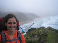 trapping my walking-stick so that i'd be thrown off-balance when trying to move forwards
-the insidious vines winding subtly around our feet for a surprise attack
-frequently not being able to see the steep and slippery path beneath our feet because of the dense foliage
-fallen trees constantly blocking the route - the worst were the ones that fell along the length of the path so as to block as much as possible; the ones falling across the path were bad but endurable
-the face that on the te araroa info sheet, this route is considered to be an 8-hour route (it took us 11 hours, including a 1/2 hr navigational error that led us to ascend a high peak twice), and the 9 miles to and from the forest are not included in the calculations.
camped, again, on the trail. cold. :(
friday, september 4 raetea forest to jackson road - 11.5 miles
had to pull out the gloves for the first time this morning. it's hard to get going when it actually feels like the winter that it is, but we were both anxious to get out of this forest and never, ever return. unfortunately, the end of the forest brings you out to SH1, the main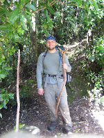 highway in northland, along which we had to walk for 7 miles. fortunately (i feel like i'm re-writing that children's book, "fortunately/unfortunately"), 2 miles into the dangerous shoulder-skirting, we were picked up by a family heading south to whangarei and were invited to join them in hamilton to be interviewed for their radio show, "cosmopolitan news and views", on the local community radio station. it sounds like fun, but after my recent television appearance, i'm a bit hesitant... :) we'll let you know if we end up doing it.
decided gleefully to avoid the puketi forest, as miles of the trail are literally walking in a stream (maybe fun if we hadn't just done the herekino and raetea forests), and take the gravel road bypass that skirts the forest to the north. haven't seen a soul in the last 4 hours, so we hope it won't be a problem. (insert dramatic gunshot story here)
saturday, september 5 jackson road to puketi recreation centre - 14 miles
not a bad section; we made great time despite some very vague directions and found ourselves at the campsite by early afternoon. we even had time for a brief stop at the kauri sanctuary, a 5-minute circle along a boardwalk that give information about the old kauri trees. our GPS gave us a strange location for the recreation centre, making us a bit concerned, but we ran into a hunter (pigs? possums? birds?) along the way who gave us some solid directions. as we ran out of cash in the surprisingly ATM-less ahipara, we had to give the DOC an IOU for staying on their property. oops. had time to let the rain fly dry out in the grass under a warm afternoon sun and even pulled out the cards for a game of rummy. nice evening.
sunday, september 6 puketi recreation centre - 12 miles (+3)
12 miles of road walking again. i'm figuring out the cultural expectations for waving to passing cars - if you're on a paved road, there's no need to wave, as the cars are rushing by to their next destination. if you're on an unpaved road, where presumably the drivers still see other humans as a novelty, you should wave a friendly hello.
i'm not growing any fonder of our GPS, as it's difficult to get an overview of the trails ahead and has given us inaccurate locations for our places of rest two days in a row now. so our hostel that was, according to the GPS, just 300 ft from the trail turned out to be 3 miles from it. thankfully, the kerikeri farm hostel had 1 room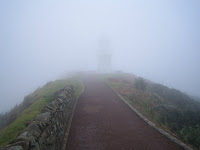 left by the time that we finally arrived and was just adorable as i'd hoped it would be. it's located on an orchard, so there are fresh oranges available for the taking and the old farmouse is quite cozy. the free internet is a bonus, too. met another american today, joel from illinois, who started biking (with no previous cycling experience) from IL to CA this summer after graduating from college, then hopped on a plane from LA to NZ and is now biking around the country solo. very cool.
it's now tuesday morning and we're getting ready to head down along the bay of islands and along the east coast. we spent yesterday running errands in town - we found a cute cafe for lunch, sent the bounce box along to whangarei, printed off trail info at the local library, found an adaptor for the camera, and restocked our food for the next week. i'm especially looking forward to today's lunch - green pepper slices, fresh oranges, and a baguette with brie. yum!
we've got a long section with (probably) fewer internet stops ahead, so you might not hear from us for about a week and a half. thanks for reading - we love coming into town and reading your comments!
rachel
PS - the pictures don't at all correspond to the sections that i'm describing, so here's an index:
1-bryan tobogganing down the sand dunes at te paki stream as part of the bus tour up to cape reinga
2-us on day 1 - when we were still excited about the journey :)
3-me on day 1 with a beautiful view of the ocean behind me
4-bryan at the exit of the raetea forest. "surely you wouldn't deprive an old man of his walking stick?"
5-the view of cape reinga on day 1 (you can just barely see the outline of the lighthouse in the middle)
 of overblogging and losing your interest. thought some of you might want a day-by-day account, though, so here it is.
tuesday, september 1 ahipara to herekino forest, 9.5 miles
a treacherous day after such a nice long rest! the first 5-mile section was road walking, the first of many, but fortunately we were able to take a break for a "cuppa" (cup of tea/coffee/etc) and some cookies at the home of karen, a friendly mother of two young kids that we first met two days ago when arriving in ahipara. she'd spent a year in casper, wyoming on a basketball scholarship in college and had also lived in the south island's university town of dunedin, so we were able to talk a bit about both where we'd come from (u.s.) and where we would be heading (south island) in a few months.
no hospitable people for a while after that, though - the forest seems to make no friends, only enemies. the track was mostly mud and climbed steeply immediately after entering. bryan remarked accurately that it felt more like a jungle than a forest. the only relief was a brief walk along the only well-formed part of the trail, an old logging road. my feet are constantly wet. camped for the night on the trail, on the flattest and driest section that we could find, which really isn't saying much. we're already behind schedule,
 having made it only halfway through the forest, and will likely have to extend this section by as many as two days. :(
wednesday, september 2 herekino forest to raetea forest - 13.5 miles
nothing to write home about here. finally struggled out of the dang herekino forest around noon, finding ourselves in a beautiful but equally muddy portion of forestry land a few miles later. at least this one was gorgeous (a real elven-style forest), with trees spaced out well enough for the sun to shine through and a creak meandering below the path. the rest of the day included more road walking (usually along low-traffic gravel roads, which isn't so bad), eventually bringing us to the start of the raetea forest, where we camped on very uneven ground (my fault - i chose the site this night) and experienced a most unrestful night. the last 3 miles of hiking, a winding road on a constant up-slope, gave us some beautiful glimpses of the sun falling on the pastureland below.
thursday, september 3 raetea forest to...raetea forest - 7.5 miles :(
the low point of the trail so far. we hate this forest. HATE it! i've spent the day bursting spontaneously into frustrated tears and muttering livid remarks about the forest and the people who created this "trail". to be fair, we should have noticed that it's listed as a route and not a trail, meaning that it's essentially bushwhacking from marker to marker. we played a game called "marker poler" to help us remember to keep looking for markers to ensure that we were on the right trail. it wasn't a very fun game :)
here's what we hated about this horrible death-forest:
-the constant mud, frequently sucking my shoes off my heels and
 trapping my walking-stick so that i'd be thrown off-balance when trying to move forwards
-the insidious vines winding subtly around our feet for a surprise attack
-frequently not being able to see the steep and slippery path beneath our feet because of the dense foliage
-fallen trees constantly blocking the route - the worst were the ones that fell along the length of the path so as to block as much as possible; the ones falling across the path were bad but endurable
-the face that on the te araroa info sheet, this route is considered to be an 8-hour route (it took us 11 hours, including a 1/2 hr navigational error that led us to ascend a high peak twice), and the 9 miles to and from the forest are not included in the calculations.
camped, again, on the trail. cold. :(
friday, september 4 raetea forest to jackson road - 11.5 miles
had to pull out the gloves for the first time this morning. it's hard to get going when it actually feels like the winter that it is, but we were both anxious to get out of this forest and never, ever return. unfortunately, the end of the forest brings you out to SH1, the main
 highway in northland, along which we had to walk for 7 miles. fortunately (i feel like i'm re-writing that children's book, "fortunately/unfortunately"), 2 miles into the dangerous shoulder-skirting, we were picked up by a family heading south to whangarei and were invited to join them in hamilton to be interviewed for their radio show, "cosmopolitan news and views", on the local community radio station. it sounds like fun, but after my recent television appearance, i'm a bit hesitant... :) we'll let you know if we end up doing it.
decided gleefully to avoid the puketi forest, as miles of the trail are literally walking in a stream (maybe fun if we hadn't just done the herekino and raetea forests), and take the gravel road bypass that skirts the forest to the north. haven't seen a soul in the last 4 hours, so we hope it won't be a problem. (insert dramatic gunshot story here)
saturday, september 5 jackson road to puketi recreation centre - 14 miles
not a bad section; we made great time despite some very vague directions and found ourselves at the campsite by early afternoon. we even had time for a brief stop at the kauri sanctuary, a 5-minute circle along a boardwalk that give information about the old kauri trees. our GPS gave us a strange location for the recreation centre, making us a bit concerned, but we ran into a hunter (pigs? possums? birds?) along the way who gave us some solid directions. as we ran out of cash in the surprisingly ATM-less ahipara, we had to give the DOC an IOU for staying on their property. oops. had time to let the rain fly dry out in the grass under a warm afternoon sun and even pulled out the cards for a game of rummy. nice evening.
sunday, september 6 puketi recreation centre - 12 miles (+3)
12 miles of road walking again. i'm figuring out the cultural expectations for waving to passing cars - if you're on a paved road, there's no need to wave, as the cars are rushing by to their next destination. if you're on an unpaved road, where presumably the drivers still see other humans as a novelty, you should wave a friendly hello.
i'm not growing any fonder of our GPS, as it's difficult to get an overview of the trails ahead and has given us inaccurate locations for our places of rest two days in a row now. so our hostel that was, according to the GPS, just 300 ft from the trail turned out to be 3 miles from it. thankfully, the kerikeri farm hostel had 1 room
 left by the time that we finally arrived and was just adorable as i'd hoped it would be. it's located on an orchard, so there are fresh oranges available for the taking and the old farmouse is quite cozy. the free internet is a bonus, too. met another american today, joel from illinois, who started biking (with no previous cycling experience) from IL to CA this summer after graduating from college, then hopped on a plane from LA to NZ and is now biking around the country solo. very cool.
it's now tuesday morning and we're getting ready to head down along the bay of islands and along the east coast. we spent yesterday running errands in town - we found a cute cafe for lunch, sent the bounce box along to whangarei, printed off trail info at the local library, found an adaptor for the camera, and restocked our food for the next week. i'm especially looking forward to today's lunch - green pepper slices, fresh oranges, and a baguette with brie. yum!
we've got a long section with (probably) fewer internet stops ahead, so you might not hear from us for about a week and a half. thanks for reading - we love coming into town and reading your comments!
rachel
PS - the pictures don't at all correspond to the sections that i'm describing, so here's an index:
1-bryan tobogganing down the sand dunes at te paki stream as part of the bus tour up to cape reinga
2-us on day 1 - when we were still excited about the journey :)
3-me on day 1 with a beautiful view of the ocean behind me
4-bryan at the exit of the raetea forest. "surely you wouldn't deprive an old man of his walking stick?"
5-the view of cape reinga on day 1 (you can just barely see the outline of the lighthouse in the middle)
Monday, September 7, 2009
Bryan's 1st Guest Appearance
It has been an interesting week for us here on the trail. We have had a lot of highs and lows, both in regards to elevation and emotions. The greatest of these came on Thursday. We spent that day hiking through the Raetea forest. This was very much unlike any of the forest or hiking that we had done in Minnesota or anywhere else. This hike included twin summits of 540 meters, which may not sound that high in the grand scheme of things, but I assure you it is, when you have big packs and boots that are caked in mud. But I'm getting ahead of myself. Before we arrived at these points of high elevation we had to be in the lows of the horribly muddy and thick, with vines and brush valleys.
I'm sure you will or have read about it from Rachel's entry, but I want to express how impressed I was with her performance. Although this part of the trail was completed fuming with rage, dripping wet from condensation (and some tears) and covered to the hip in mud, I can honestly say I would not have wanted to be there with anyone else. We didn't just beat those summits, Rachel, namely destroyed them. And on of them twice due to some confusion with the arrows and which set it was that we needed to follow.
I was afraid however that she was going to fall off one of the summits when she was ahead of me in thick brush that you could not see anything infront of yourself, though to the sides there were amazing views over the edges that I wish that would could have captured on film, but as it turns out our camera is substantially less than reliable. However, she did not fall off the edge, she was just too angry to care to linger for even a moment.
Because we are usually set up and ready to go to bed at about 7 o'clock every night, we have been reading a lot. and it was here that I found a quote that describes somewhat the feelings that I have experienced when we reach a check point, or finish a particularly difficult section of the trail. Our journey is not nearly as perilous as the journey that Ernest Shackleton had just experienced, and I hope that we are never in mortal danger as many times that he was but I feel that it reflects the sentiment that I want to have on this adventure. But I also hope that you all will have an opportunity to share in this kind of feeling at some point in time, or will be able to look back at a time that falls into this kind of experience.
That was all except our wet clothes, that we brought out of the
Antarctic, which we had entered a year and a half before with
well found ship, full equipment and high hopes. That was all of
tangible things; but in memories we were rich. We had "suffered
starved and triumphed, groveled down yet grasped at glory,
grown bigger in the bigness of the whole." We had seen God in
his splendors, heard the text that nature renders. We had reached
the naked soul of man.
-Sir Ernest Shackleton, South: the Endurance Exposition
Bryan
Sunday, September 6, 2009
resting in kerikeri
hi friends and family! i'll update in detail tomorrow (i believe bryan is also preparing a guest blog), but we just wanted to let you know that we arrived in kerikeri this afternoon with some very muddy gear and bodies that were much in need of a long...very long...shower. if my rough calculations are correct, we have completed about 125 miles in 11 days of hiking - much less than the 15 miles per day that we originally and naiively hoped for, but still a total that we're proud of. i'll leave you with one story that sticks out in my mind from this last section (ahipara to kerikeri):
the night before last, we were in the middle of a 23-mile section that was almost exclusively road-walking, meaning no campsites or hostels at which to park ourselves for the evening. we finished an adequate number of miles for the day along an old gravel logging road and, with dense bush on both sides and having seen no one on the road all day, pitched the tent on the side of the road in a grassy spot. around 10 pm, we heard a loud, explosive sound which sounded like a shotgun (though, to be fair, i take every loud noise to be a gun) and male voices coming up the road towards us. we stayed huddled in our sleeping bags, hoping that they wouldn't spot us, but as they passed our way, a teenage voice shouted, "what's that over there? is that a pup tent? who the hell would be sleeping out here?" and flashlights streamed in through the tent's thin nylon walls. when they asked if anyone was in the tent, i shouted a brief reply, and they soon stalked off down the road again.
about a half hour later, we heard the voices coming closer again, and waited to see if they would let us sleep (our bedtime is, at the latest, 8 pm) this time. just as they rounded the bend to stand on the road just above us, i heard another shot, close at hand, and someone saying "shoot, i missed". at the same time, the flashlight beams were targeted at our tent again and a young voice began quizzing us about whether we were tourists and where we were going. i expected another shot to pierce our tent walls and kill us there, along jackson road, at any minute. fortunately, bryan answered their questions satisfactorily and they eventually wandered back off into the night with a few shouts of "stay off our land!" they didn't return again, at least not while bryan kept watch (another 3-4 hours, i think - waking me up every time he bolted upright at some new unfamiliar sound).
what we've pieced together from our best guesses and a friendly interaction with, we think, a couple of the same guys the next morning is that they were just possum-hunting teenagers from the nearby maori settlement who happened to spot a possum near us on the road, which they shot at and missed. in the dead of night, in the isolation of the kiwi backcountry, and with the limited analysis that drowsiness provides, this casual encounter seemed like deadly peril.
hope you enjoyed our drama :) again, i'll update in more detail tomorrow. hope you're enjoying your labor day weekend!
rachel
Subscribe to:
Posts (Atom)
